Map Navigation - Help Pages
|
|
|
|
|
|
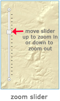
The zoom slider allows you to zoom into the map by moving the square slider up and zoom out by moving the square slider down.
|
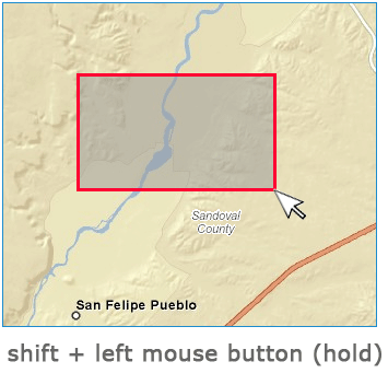
To zoom into a specific place on the map, hold the shift key and your left mouse button down then drag your cursor from top-left to bottom-right of the feature.
|
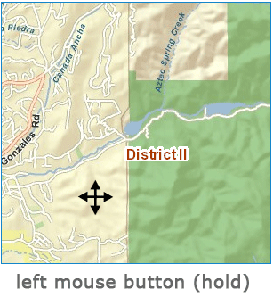
To move the map up, down, left and right, position your cursor somewhere on the map. Hold down your left mouse button until you see your cursor change to a four arrow pointer then move the map in the direction you want it to go.
|
|

|
|
 The scale readout reports the scale of the map. You can also type in a number, such as 1:24000, or simply 24000, and hit enter and the map will zoom to that scale. For efficiency, there are preset zoom levels, so the map will zoom to the closest cached zoom level. The scale readout reports the scale of the map. You can also type in a number, such as 1:24000, or simply 24000, and hit enter and the map will zoom to that scale. For efficiency, there are preset zoom levels, so the map will zoom to the closest cached zoom level.
|
|
 The zoom lollies allow you draw a box to zoom in on, just like the shift + left mouse button, above. The zoom lollies allow you draw a box to zoom in on, just like the shift + left mouse button, above.
|
|
 The pan tool allows you to pan around the map by clicking and dragging the page, just like the left mouse button, above. The pan tool allows you to pan around the map by clicking and dragging the page, just like the left mouse button, above.
|
|
 The extent button zooms to the full extent of New Mexico. The extent button zooms to the full extent of New Mexico.
|
|
 The zoom center buttons zoom in or out on the center of the current map view. The zoom center buttons zoom in or out on the center of the current map view.
|
|
 The previous and next extent buttons can be used to go back to the last view extent or forward to a more recent one. The previous and next extent buttons can be used to go back to the last view extent or forward to a more recent one.
|
|
|
|
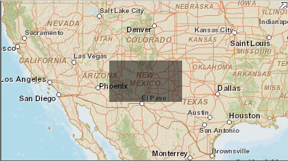
The minimap can be used to pan. Click and drag the shaded rectangle, which represents the main map view, and drop it where you want to pan to. Environmental data is only available in New
|
|
page last updated
|