{linklabel}

Information Tools - Help Pages

Information Toolbar

 The information toolbar has tools that allow you to get detailed information on each feature, measure distances, draw your own shapes on the map, or find a location by address.

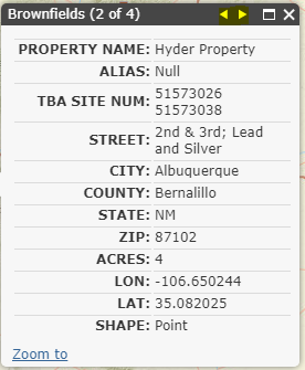
 The identify tool will return detailed information about a feature on the map.

To use it, click on the button in the toolbar until your cursor changes to the identify cursor .

Click a feature on the map.

A popup will appear with attributes, and arrows to click through if multiple features are selected, like so:

 The Measure tool lets you measure distances or areas in your chosen units.

Set whether to measure length or area, choose your units, and start drawing a line or polygon on the map. Please Note: distances and areas are only approximate! Projection from a spherical globe onto a flat screen introduces distortion in both the shapes and distances depicted on the screen.

 The Go To XY tool allows you to pan and zoom in to an arbitrary latitude and longitude.

Type in a latitude and longitude and click the Zoom To

 The Draw Circle tool allows you to draw your own circles of arbitrary radius on the map.

Type in a radius, pick the units of the radius, and click on the map where you wish the center of the circle to be. Note: drawing a new circle will erase the old one.

 The Locate Adress tool will find an address on the map.

Type in an address, as much specific information as you know, and click Locate. Alternately, you may select to located a named place, such as "Bob Crosby Draw" and click Locate. The server will attempt to locate the address or place and zoom in to it. There may be more than one good match.

 Click Deactivate Cursor if you wish to return to a simple mouse pointer or erase a circle you drew on the map.

page last updated
©2012 New Mexico Environment Department. All Rights Reserved